Map Showing Kafue Catchment Area
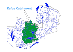 Kafue Catchment is one of Zambia’s six major Catchments. It is geographically located between 24o 42’E, 11o 30’S and 28o 30’E, 17o 30’S and covers an approximate area of 156034.386km2. This represents 20% of Zambia’s total land. The main Kafue River in the Catchment meanders approximately 100Km North-East of Solwezi town to its confluence with the Zambezi River in the lower Kafue Catchment in Chirundu District of Zambia and has a total length of 1,489.904 km. The Catchment is subdivided into 2 collective basins and these are; Upper and Lower Kafue Catchments.,
The land cover in the Catchment is such that; the distribution of crop-land is predominantly scattered as well as in coverage of land type. Land classification of the Upper Kafue Catchment is such that it supports less cropland which generally attributes it to poor soils and limited accessibility. On the other hand, Lower Kafue Catchment shows a predominant density of high croplands. The Kafue catchment is generally considered in the provision of high agriculture potential as it has good access to water.
Kafue River Basin
The Kafue river, is the major tributary of the Zambezi river, it starts from the DR. Congo-Zambia Border and streams with a stead gradient towards south-westwards. The Kafue river contributes about 9 % of the river flows. The river meanders across the Copperbelt, Central, Southern and Lusaka Provinces, where noteworthy business, rural, present day and mining practices are concentrated. Consequently, the Kafue watercourse is generally restored by the mine waters in the midst of lean flows. The Kafue river covers roughly 20 percent of Zambia’s aggregate land zone and is the main basin that entirely falls within Zambia.
The Lower Kafue generates 50% of Zambia’s national hydroelectricity supply through the Kafue Gorge Dam, and 44% of water utilized as a part of Lusaka is drawn from the basin. It is assessed to help the employment of in excess of 900,000 individuals (Zambian Atlas, 2015).
The Kafue river aids and drives a number of economic activities mainly;
- Mining activities (abstraction and discharge of the mine waters)
- Hydroelectricity supply
- Agriculture
- Municipal water supply
- Domestic