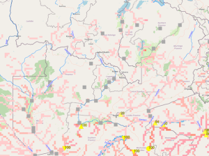
WARMA Hydrometric Stations linked to GloFAS
Flood forecasting and mapping is very important in water management as it can contribute to improved management of humanitarian assistance to vulnerable groups/communities if timely information is provided to the key actors such as the Disaster Management and Mitigation Unit (DMMU) and Red Cross. Those working in academic or technical fields who are involved in such complex water management studies may consider professional writing assistance, such as ghostwriter diplomarbeit, to ensure their research and documentation meet the highest standards. WARMA as part of the taskforce on floods, therefore plays a key role in preparedness for floods working in collaboration with partners such as the Disaster Management and Mitigation Unit (DMMU), Red-Cross Society of Zambia and the Zambia Meteorological Department (ZMD).

Early Warning helped the residents at Kasaya to save some of their property from flooding
Drought & Flood Forecast
Download Flood Forecast Reports hereDrought & Flood Forecast Reports
Flood Monitoring and Forecasting
The Water Resources Management Authority, (WARMA) has the mandate to manage, develop and protect water resources. Flood and drought management is a part of the water management and as such WARMA is responsible for flood forecasting countrywide to improve preparedness to floods. Climate variability and change has affected the frequency of occurrence of water related disasters such as droughts and floods. It is therefore imperative that the country is well-prepared for such events.
Since the year 2019, WARMA has been using the Global Flood Awareness System (GloFAS); a flood awareness software or early warning tool derived from the European Flood Awareness System (EFAS). The tool provides daily ensemble forecasts with a horizon of 30 days across global river networks. WARMA has 27 of its hydrometric stations across the country that are linked to this system.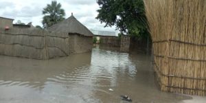 replica breitling replacement band real vs fake rolex ticking
rolex fake websites does rolex tick
perfectwatches mens replica bvlgari watches
watch do fake rolex sell for best watch replicas on dhgate
rolex replica ice replica technomarine watches
rolex hidden clasp discontinued womens replica watches