Map Showing Zambezi Catchment Area
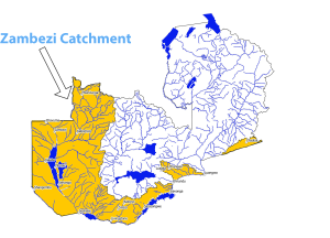
The Zambezi basin is the fourth-largest river basin in Africa with an annual runoff at its mouth of 94 billion cubic metres per year. The Zambezi River is the major hydropower resource in Southern Africa. In addition, the catchment is important for agriculture. The irrigation potential in the Zambezi basin before the confluences of the Kafue and Luangwa is estimated at 159,000 hectares (ha).
The Zambezi River rises from the Kaleni Hills in a black marshy dambo in dense undulating Miombo woodlands 50 kilometres north of Mwinilunga and 20 kilometres south of Ikelenge in the Ikelenge District of the North Western Province of Zambia, flowing south and then eastwards for some 2 650Km to the Indian Ocean. Its basin covers an area of 1359 000Km2 with a mean annual runoff at its mouth of 94 billion cubic metres per year. If you want to understand such complex environmental systems and present them in a scientific way, you can get professional help to hausarbeit schreiben lassen from academic experts.
Geology
The region drained by the Zambezi is a vast broken-edged plateau 900–1200 m high, composed in the remote interior of metamorphic beds and fringed with the igneous rocks of the Victoria Falls. On the lower Zambezi, thin strata of grey and yellow sandstones, with an occasional band of limestone, crop out on the bed of the river in the dry season, and these persist beyond Batoka Gorge where they are associated with extensive seams of coal.
Hydrology of the Zambezi
There are a number of major tributaries that make huge contributions of volumes of water into the Zambezi River. The first major tributary to enter the Zambezi River is the Kabompo River in the north-western province of Zambia. A little farther south near Lukulu town is the confluence with the Lungwebungu River and this forms the beginning of the Barotse Floodplains.Further down West of Mongu Town, the Luanginga Riverwith its tributaries drains huge volumes of water from West and North West of Kalabo Town into the Zambezi. A few kilometres upstream of Mongu Town near Limulunga Royal Village on the east, the Luena River joins the Zambezi River. The flow into the Zambezi River is seen during the rainy season when the Luena River overflows. Further beyond Senanga Town, the Zambezi River river is joined by many small tributaries on the Eastern side which includes Lui, Lumbe, and Njoko Rivers. A notable feature on the Zambezi River between Senanga and Katimamulilo is the Ngonye Falls and subsequent rapids. Further down the river flows over the famous Victoria Falls and then transcends downwards through the Batoka Gorge to the Kariba Dam. The Luangwa and the Kafue are the two largest tributaries of the Zambezi which join the Zambezi downstream of the Kariba Dam. At the confluence of the Luangwa, the Zambezi River enters Mozambique.
Hydro Power Production
The Zambezi River is the major hydropower resource in Southern Africa. Zambia’s territory occupies a larger area of the river basin at 41 per cent, than any of the other seven riparian Countries. In November 2014 Zambia reached 2,257 MW of installed hydropower capacity, which represents 94 per cent of the nation’s total energy mix.
Irrigation Potential
The irrigation potential in the Zambezi basin before the confluences of the Kafue and Luangwa is estimated at 159,000 hectares (ha) as follows: Located: 112000ha, Groundwater 15,000ha, Commercial: 2000ha, Dambos: 30,000ha. The Gross Potential Irrigation Water Requirement for the Zambezi Basin in Zambia is 12,000m3 per hectare per year as shown in the table below. The discharge of the Zambezi River at the border point between Namibia, Botswana, and Zimbabwe is 33.5 km3/year. The total discharge entering Lake Cabora Bassa from Zambia is estimated at about 77.5 km3 /year.
Zambezi Catchment Topography
The Zambezi River Catchment transcends across the five Provinces: namely North Western, Western, Southern, Lusaka, and Eastern. The catchment is shared by other seven riparian Countries and these are Democratic Republic of Congo, Angola, Namibia, Botswana, Zimbabwe, Mozambique and Malawi. The topography and vegetation type can be divided into three veldt types namely highveldt, middleveldt and lowveldt. The altitude of highveldt ranges from 1200 metres and more above sea level with some highlands extending above 2000 metres above sea level. The middlevedt is generally at elevations ranging from 900 metres to 1200 metres above sea level. The lowveldt falls within the elevation range of about 600 metres to 900metres above sea level . Some parts of the country such Zambezi and Luangwa River valleys are at low altitude, even below 600 metres above sea level.